Are you like me, constantly looking at maps to see exactly where your family once roamed? I’m always using the below map on the FamilySearch Wiki to solve brick walls, wondering where my next further back batch of relatives would come from or lived in relation to others.

Just about all the relatives on my paternal side are found within the counties in the South-Western/Central portion of Pennsylvania. These counties would be Somerset, Bedford, Fulton, Cambria, Blair and Huntingdon counties. But not all of these counties have always existed, at one point I believe most of the region was Bedford County (which is why I chose Bedford to visit in July 2019).
Maps can be very helpful for locating where your ancestor’s records are kept. Records tend to stay with the county of when they were created. So if your family’s land is in what is now Blair County – since it was formed from Bedford County and Huntingdon County – if the records you seek are prior to 1846 – you will need to look in either Bedford or Huntingdon Counties.
An article on GenealogyBank.com by Gena Philibert-Ortega states, “Maps help you follow migration patterns, learn more about the place your ancestor lived, determine the location of cities that no longer exist, show changes in county boundaries, and verify land your ancestor owned.”
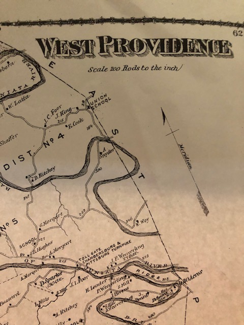
You may be lucky enough to find a map that even shows where your ancestors lived without your even plotting it. Below is a map that I photocopied out of the “County Atlas of Bedford Pennsylvania” and it shows the land where both my 2x-Great-Grandfather lived (G. Morgart) and my 3x-Great-Grandfather lived (A. Morgart). It turns out B. Hughes is a distant relative as well, and he married my 2x-Great-Grandmother when George Morgart passed away. I’m most likely related to the Ritchey’s as my aforementioned 2x-Great-Grandmother was Mary Ann Ritchey, and she had 2 brothers with the first name beginning with D.
Gazetteers
According to Wikipedia, a gazetteer is “a geographical dictionary or directory used in conjunction with a map or atlas. It typically contains information concerning the geographical makeup, social statistics and physical features of a country, region, or continent”.
These books are essential as they normally list the names of places that may not even exist in an area anymore, which can be very important for finding information on your family. Gazetteers can also provide the history of an area, including photographs.
David Rumsey Map Collection
A great website to find historical maps is the David Rumsey Historical Map Collection. The collection began about 30 years ago and includes over 150,000 maps spanning between the 16th through 21st centuries from across the world. The digitizations began in 1996 and include over 95,000 pieces. The real pieces are housed in the David Rumsey Map Center in Stanford library.
Mapping Software
If you find yourself trying to purchase a ton of books to find the maps you need, you can always turn to mapping software for computers. These programs work by you typing in your location and then you can scroll through the years watching the boundaries change before your eyes, giving you the exact county within your state (if in the United States) of where your ancestor lived at a specific point in time. This makes it convenient so you know where to look for the records you seek (remember, records stay with the county).
Examples of these programs are AniMap, Family Atlas, or you can go the free route and use Google Earth. One of the nice features of using Google Earth is that it is programmed with some of the David Rumsey maps that you can overlay where your ancestors lived at various points in history, so you can walk where they walked, so to speak (please note you’ll have to download the software for your computer for the Rumsey maps to work, but don’t worry, it’s still free!).
Just Google It
One of the other functions I used for my more recent ancestors is simply putting the address of where my ancestors lived that I have found using City Directories in Google so I can see the homes where my family members once lived. More often than not the house is still standing (I will often refer to the real estate tax site for my county as well just to confirm when the house was built). By seeing what the house looks like in advance I am able to drive by and find it more easily.
My mother’s side of the family settled where I live around 1916 and a majority of her side of the family is still here. Because of where they originally made their home each day when I drive to work I pass where my great-great-grandmother and her husband had their store. And I found it using the City Directory to obtain the address and putting the address into Google.

In a Nutshell
Maps offer us so much information. They are visual so it can open up an entirely new world to your research. You can see how far apart relatives live. If you’re tackling a brick wall and you see someone far away from any other place they’ve lived it might have you question “Is this person mine?” as the migration patterns can become quite apparent once you begin plotting addresses.
I’ve always referred to maps in my search for my family history, but I am at the point I’m really going to start plotting out where they lived just to get a better idea of where their proximity to others so I can wrap my head around things.
If you have used maps please feel free to share your tips and what you use to visually track your relatives and get a feel for where they lived.